Dubois County owes a little historical marker quite a bit

How important is a little marker located a little more than a mile south of Haysville on U.S. 231?
Pretty important if you are a prospective property owner at the turn of the 18th century trying to establish your life in the Northwest Territory of the burgeoning United States.
“The reason Abraham Lincoln’s father and a lot of other people moved to Indiana was because Kentucky did not have a uniform method of surveying land,” County Historian Art Nordhoff Jr. explained.
That marker — Buckingham’s Base Line historical marker — is the point of reference for where the base line crosses through Dubois County. The creation of all the deeds in the Northwest Territory, an area that encompasses Indiana, Ohio, Illinois, Michigan, Minnesota and Wisconsin, are based on this line running east to west and another running north to south that travels through Orange County.
Established between 1804 and 1805 during Thomas Jefferson’s presidency, the base lines created a reference point for surveyors to mark off rectangular quadrants and establish property lines in the growing territory. Property owners knew they had a secure deed to the land mapped in this manner.
“Before this, it was difficult for people to know what they owned (property-wise) and what they didn’t,” Nordhoff said.
These days, we don’t necessarily think about how important that little marker located near West 600N is — a car crash took out the sign marking the historic point actually.
But for Abraham Lincoln’s father, Thomas Lincoln, that reference point was really important.
While living in Kentucky, Thomas Lincoln established two farms — one in which the 16th President was born — and subsequently faced competing claims against both those properties. Unable to afford a court battle, he simply gave in and decided to move his family to Indiana where the baseline had established a reliable system of determining property lines.
Another person that found the base line to be important was Toussaint Dubois, the namesake of the county. He was the first person to purchase land in this area when the land office opened in Vincennes in 1807. The Dubois County Museum has Toussaint Dubois’ deed containing Thomas Jefferson’s signature on display. According to Nordhoff, the existence of the physical copy of one of these early deeds is extremely rare.
The State Legislature named the county after Toussaint Dubois because he was a hero of the Battle of Tippecanoe and the War of 1812.
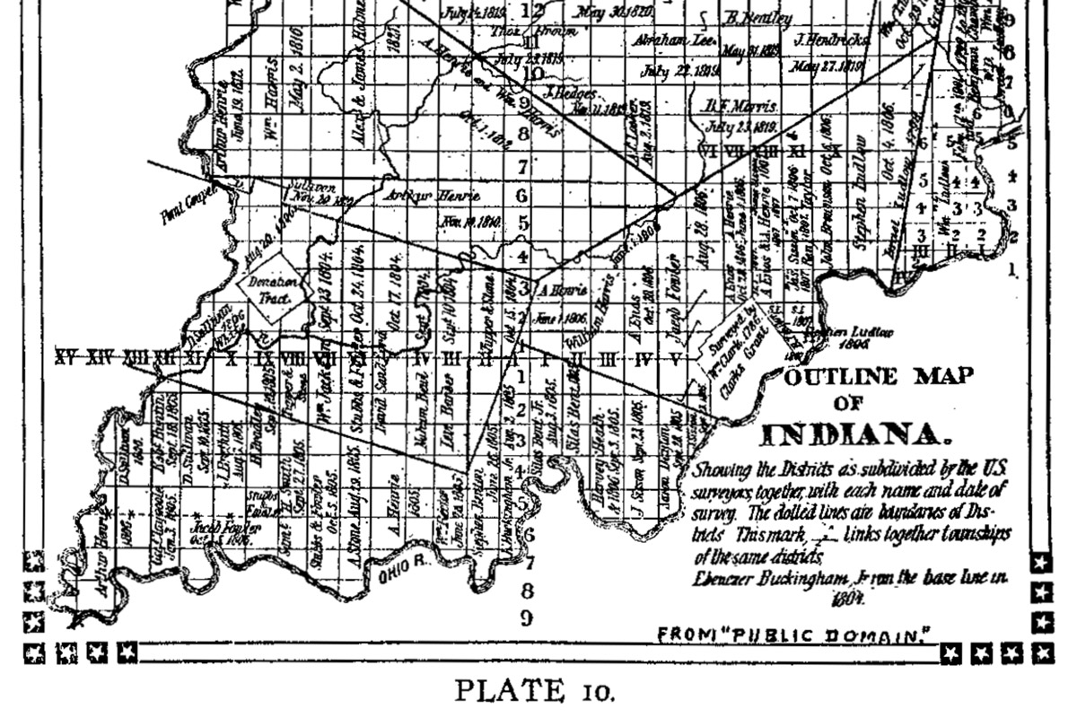
Ebenezer Buckingham, Jr. led the crew that marked these lines in the landscape. The line marked by the Roman Numerals in the above map is the east to west base line that crosses through Dubois County. It intersects the Second Principal Meridian, which runs north to south, in Orange County at Pivot Point. That line is numbered as well.
Incredulously, to establish the line and measurements, Buckingham in crew started in Vincennes using a 66-foot long chain made up of about 100 individual links to create the base line through the wild territory of Indiana. One can imagine them eyeballing the length of the chain ensuring it was running due east in a straight line, marking the end point on a tree and then dragging the chain another 66 feet to a new point due east.
The Dubois County Historical Society has provided for the installation of a new Buckingham Base Line historical marker at that point on U.S. 231 near 600N, a road also known as Baseline Road, in honor of the 200th Anniversary of Dubois County.
The historical society successfully applied for the historical marker to the Indiana Historical Bureau by submitting a detailed written report with required documentation, providing funding for the marker, making arrangements with the landowner for the location of the sign, and surveying the land for the installation of the marker. Phyllis Menke of Huntingburg provided a generous donation toward the marker project. The Haysville Ruritan Club also contributed to the project which was funded primarily by the Dubois County Historical Society.
This Saturday, the Dubois County Historical Society will host a dedication ceremony at 1:00 p.m. EST on US 231.
Dubois County Surveyor Ken Brosmer and a representative of the Indiana Historical Bureau will speak at the dedication ceremony. Brosmer, Nordhoff, Dubois County Historical Society President Mary Ann Hayes and Historical Society Treasurer Fred Clark make up the Buckingham’s Base Line Historical Marker Committee.
The public is invited to attend the dedication. Since there are few parking spaces, attendees are strongly encouraged to car-pool and to be cautious while parking along the busy highway. After the dedication ceremony on Hwy 231, many of the participants plan to go to Haysville Park, 7210 N. Haysville Park St., where the Haysville Sommerfest is being held and will be available to discuss Buckingham’s Base Line.

While a strong believer in purist history (unaltered to suit the PC or revisionist agenda, etc), but all-too-aware of those peoples and groups easily offended, it’s hard to figure nowadays how the last few words – “after removal of Native Americans.” – on the first side of the marker were included. It could have just as easily and no less accurately ended with the last word in the previous sentence – “settlers” – but without the risk of attracting the ire of anyone. As is, I hope it doesn’t.
Although I appreciate the significance of establishing a much needed system of property measuremen,m I am truly surprised those words were included. “After removal of Native Americans”, obviously accentuates the fact that the land was stolen from Native Americans by the settlers and government. Of course there was a time in our history when conquering to attain wealth was acceptable. This must also be recognized.
Trying to pursue history in a PC manner is not pursuing history!!! Lest we lose all in translation. Just to appease those who don’t know where to pee happy!