A lot of wind damage, but Dubois County fares better than surrounding counties
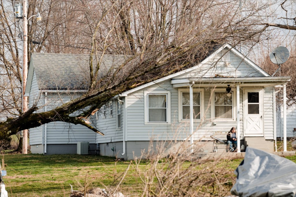
Wind damaged homes and structures throughout Dubois County during the early Saturday morning storm, which also caused several tornadoes in neighboring counties.
“Dubois County fared incredibly well compared to other counties in District 10,” said Dubois County Emergency Management Director Tammy Humbert. “Gibson, Pike, Daviess, Martin (counties) were impacted pretty bad.”
The National Weather Service has reported an EF-2 tornado with winds estimated to peak at 115 mph, touching down five miles west of Somerville in Gibson County. An EF-2 with peak winds of 117 mph touched down in Oakland City, and an EF-2 tornado with an estimated 120 mph winds touched down in Algiers in Pike County. The National Weather Service is working to determine if this was a single tornado.
In Daviess County, the National Weather Service found evidence of an EF-1 tornado, with estimated peak winds of 110 mph, traveled over 13 miles northeast past Dogwood Lake and towards Loogootee.
Monday evening, the National Weather Service determined this was a single tornado in Southern Indiana that traveled 47 miles across Gibson, Pike and Daviess counties, crossing I-69 in the process. With wind speeds from 111-135 mph, the tornado began just east-northeast of the Tri-State Speedway near Haubstadt.
Humbert pointed out that straight-line winds can be as damaging as a tornado.
The timing of the storm was especially problematic for Humbert. Knowing it was likely hitting in the middle of the night or early hours of the morning, she spent the week leading up to it reminding the public to have a way to be alerted.
“Fortunately, people took it seriously, at least the ones I have talked to did,” she said.

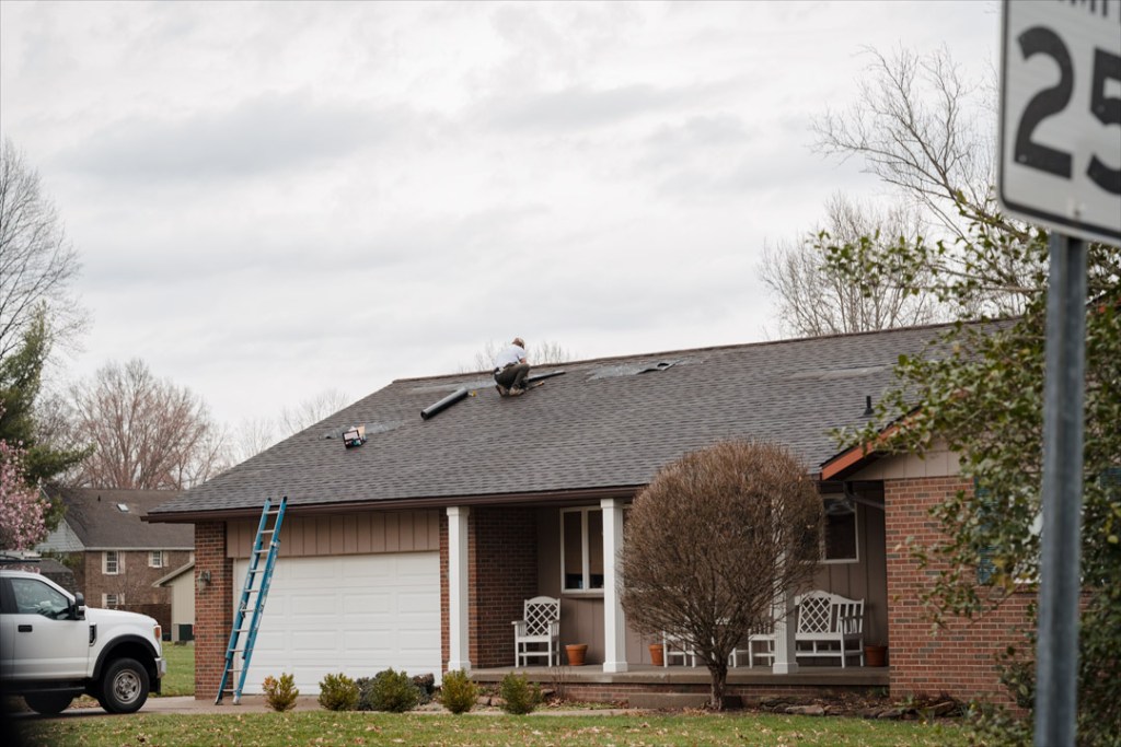
Humbert said that no one in Dubois County had been displaced by damages to their residences. “We had lots of widespread damage, but it was shingles off of roofs, siding being hit, soffit being pulled down, porches kind of being pulled apart,” she explained. “And everyone that I spoke with, which was over 80 individuals, all had insurance and were contacting their insurance companies, either over the weekend or today.”
Utility poles were extensively damaged throughout the county, causing road closures as crews worked around the area to repair downed lines.

According to Dubois REC CEO and General Manager Joe Henson, more than 3,800 customers were initially out of service. “We had major damage to our entire service territory,” he said.
That area covers all of Dubois County, parts of Martin County, Orange County, Perry County, Pike County and half of Crawford County.
“If you looked at the outage map online you would have seen outages everywhere,” Henson said.
Henson said they had more than 30 broken poles caused by the wind, whether directly on the poles and lines or by broken limbs and toppled trees.
Crews worked all day throughout the network on Saturday and only had 86 members without service by about 9 p.m. That number increased again overnight Sunday as bad weather intensified again. “We had over 100 members [without power] on Sunday morning,” Henson said.
As of Monday afternoon, about 20 to 25 customers remained without power.
Wind damage included snapped poles, limbs, and trees taking down lines.

He commended the public not only on how they treated crews and for understanding the difficulties they faced in repairing the downed infrastructure but also for their neighborliness.
“The community was excellent,” Henson said. “We were getting words of encouragement. We’re grateful for that.”
Community members offered to help however they could, whether with chainsaws, tractors or other equipment to move downed poles and trees.
“Our crews were offered food or something to drink. They just treated us really, really well,” Henson said, adding they were very thankful for the support and understanding from the community.
He explained that their limited crew can sometimes call on other utilities to assist with the work, but Saturday’s storm was so widespread that everyone was busy.
Henson reminded the community to be careful as limbs and trees weakened by the storms could still break or fall. “You don’t know what else the wind might have damaged out there,” Henson said. “And if you see a line on the ground, it doesn’t mean it is de-energized. Keep your family away and call us or call authorities immediately.”

Jasper Utility Superintendent Stan Seifert said that as of Monday, they had two or three customers without power, down from the 1,475 without power Saturday morning after the storm went through.
“We had most of them back on within about two to two-and-a-half hours,” Seifert said.
Along with lines damaged by the wind, limbs and trees, Jasper had about 20 utility poles broken. These are being replaced, and 12 remain in place as crews continue to work to repair the damages.
According to Seifert, one major pole damaged in the storm located on Mill Street will need to be replaced. Mill Street will be closed on Wednesday, north of 30th Street, as crews complete the work.

Along with the high winds, the area received 2.5 to 3 inches of rain over the weekend, causing several county roads to be flooded.
The county reported the nine closed Monday morning. That number fell to seven by this afternoon. Here are the roads impacted by high water.
In Madison Township, County Road 875 West south of County Road 150 North; County Road 150 South west of Old Huntingburg Road; and Ell Creek Road north of County Road 400 South are closed.
In Bainbridge Township, Old Huntingburg Road north of County Road 400 South is closed.
In Patoka Township, County Road 400 South west of Ell Creek Road; Old Road 64 west of Patoka Road; and Huntingburg’s First Street west of County Road 75 West are closed.
Huntingburg Energy Superintendent John Reutepohler did not return a call in time for Monday’s publication. This story may be updated.
